Sept 18 my wonderful mother-in-law agreed to watch the kids so that Cynthia and I could have a date night. While some couples grab a coffee and take a walk, we decided to head up Mt Archibald and connect it into the summit of Mt Cheam via the west ridge trail.
While this trail has sort of existed for decades, it’s been more a mere suggestion of a route to take until the last 12 months. Three years ago I got on the route and made it past the summit of Archibald I rarely saw any markers and had to turn around before I connected Archibald with Cheam.
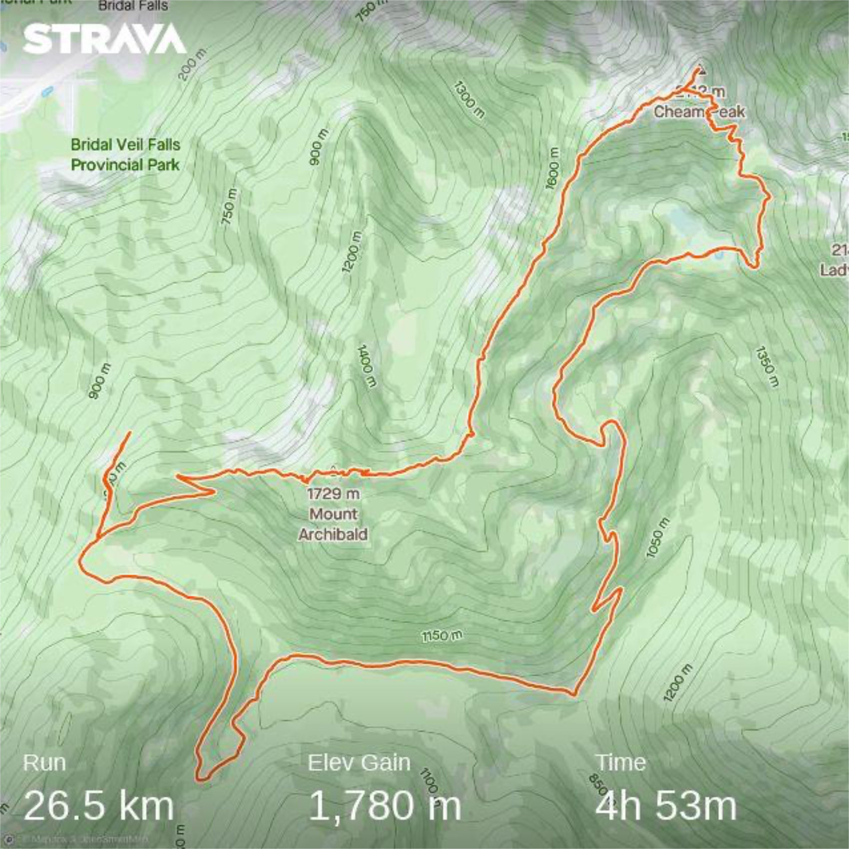
To get to the trailhead go to Bridal Falls and head towards the Bridal Falls Waterpark. Take a right towards the waterpark and then a left on Popkum Rd South. Within about 1km you should hit a gravel road and see a yellow gate in front of you. Take a left and head up the main road, keeping to left forks. You should encounter the trailhead as the trail narrows in front of you at around the 7km marker at approximately (49°09’42.3″N 121°44’31.1″W).
Be warned, this trail is rough. We’ve got our RAV 4 up there, but it’s got a short wheelbase and doesn’t high center easily. My friend pulled the steps on the side of her truck off this summer heading towards the top.

We got on the trail around 1800 to light rain and had one big thunder crack. It was nice to be above the smoke, though cloud cover was still low making visibility not more than around 100m. We headed up the trail that parallels the ridge and starts by heading back towards Chilliwack. After about 1km the road heads over the ridge and you say goodbye to any hint of cell reception for a while.
Once we crossed the ridge we headed left to follow the logging road towards the summit of Mt Archibald. Just before you reach 2km from the trailhead, the trail heads off the “newer” road and onto it’s older version. This is currently heavily flagged but it does take a turn almost directly over your left shoulder. From here the trail is steep and has a few minor scrambles but is well marked all the way to the summit of Archibald at about 4km from the trailhead.
On a nice day or clear night you’ll be treated to stunning views of Cheam. We didn’t have that though with cloud cover in low. We could barely make out the mountain’s outline, but that’s it.


After Archibald, the trail got harder to find. While there is some flagging and in spots there is an obvious trail, we were at times down to visibility of barely 1-2m in the fog. Luckily I had been on a decent chunk of the connection and had an idea of the right direction to head as we continued on. In general, you need to have decent route finding skills and you cross a few minor ridges and dips to get on the proper ridge for Cheam west.
We persevered and found the flags needed, even adding some of our own once we figured out the next step. Still going was slow with many kilometres taking 20+ minutes as we dealt with low visibility on a trail that hasn’t been travelled all that much. We regularly saw points that would be excellent vistas of Cheam, Lady, Bridal Falls, that were filled with cloud.
Around the 7.5km mark you’ll see an obvious trail heading off to the right that takes you back down to the parking lot of Cheam. This is where you decide if you’re up for some actual 5th class scrambling and route finding over the cliff bands that make up the West Cheam ridge, or if you’re going to dip down to the parking lot and head up the regular route.
We headed up the main ridge and found the trail fairly easily until we hit a bit of an slab chimney. Here we really had to focus. Visibility was still around 1 meter which meant we couldn’t move fast and couldn’t see if the next 2 meters of movement would head us towards a cliff that was hard to reverse off of, or would end with us standing on an easy spot to regroup and find the route.
My GPS track may say that km 9 and 10 were quick, but only because we moved so slow Strava removed a bunch of time that it feels we were standing still. Trust me, we were continually moving and figuring out the route while fighting visibility and cold winds. I’d guess those last 2 km took us around an hour, not the 26 minutes Strava says.
These last two kilometres before the summit felt very committed as well. Both Cynthia and I found the going stressful and challenging. Once we completed them and were on the ridge, we both agreed it was clearly type 3 fun given the conditions, as in not fun at all while we were doing it, but it would probably make a good story later. We both agreed, that a slip would have meant SAR and injury.
Now take that warning, but realize that only one or two short spots were truly “hard” climbing. The rest was walking along ridges where you could stop and talk easily. If it was a clear night and a warm night, the route would have been much easier. Fighting cold wind and visibility sucks.
We didn’t even realize we had gained the summit until we almost ran into the bench that sits out in the open. I was about half a meter away from it before I saw it, which also means you’re two steps from walking off a cliff. We quickly and carefully walked up to the summit of Cheam, and then turned around. On the way down we didn’t see the bench at all and almost ran into the circular rock shelter at the sub-summit where we adjusted layers and carefully made our way down to the mountain.
With about 5 hours of movement under our belts we topped water up at Spoon lake and then made a bathroom pit stop before we got to the parking lot. I had held out hope that we may head back up from the parking lot and retrace our steps to Archibald, but given the route finding difficulty between the two ridges, we opted for the longer route of heading down the logging road and connecting it into Bridal Falls.
We were both feeling tired so it was jogging downhill and then power hiking up over the logging road while having good chats about raising our kids, faith, money, and the stupid people that leave dirty toilet paper within sight of an outhouse.

Getting to the road where we had crossed into the Chilliwack River Valley, we could see that the clouds had lifted and smoke had cleared and got a picture of the city lights. We then jogged the last bit to the car arriving around 0215 on Sept 19. The drive down took about 45 minutes, yup the road is rough.


We arrived back in town around 0345 had a shower and got in bed for 0415.
So Was it Fun
Cynthia is of the opinion that the views you’d obviously get on Archibald are absolutely worth the work it takes to get there. She’s not sure that the West Ridge of Cheam is something she wants to take on. She doesn’t think it’s a good idea for me to do it solo either, which I agree with 100%.
I plan to head back up on the route with someone when I’m not fighting visibility. Preferably in the day when I get to enjoy the views, but knowing the exposure that is on the route and the scrambling difficulty I wouldn’t just take any of my running partners. You’d need to know what you’re getting into and be comfortable moving over terrain where a slip could be fatal.
Overall, we’re happy we did it safely and we both think that we made the right decisions. One we passed the one sloped chimney we were past the point of reversing the route safely so pressing on was the order of the day.
It’s also entirely possible that there is a bit easier route we were unable to find in the low visibility.
Just be prepared if you want to tackle this.
You can see our GPS track below.